 GOMCON 2022
Great News - Last Wednesday at the GOMCON meeting in Baton Rouge, at the EPA's Gulf of Mexico Program's Gulf Guardian Awards, the Gulf of Mexico Seagrass Monitoring Community of Practice was awarded the 3rd place Award in the Partnership Category
 Progress
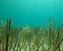
 Dauphin Island Sea Lab Tier 2 survey work continues for Mobile Bay
 Products
As a key component of the 2020
Seagrass Status and Trends Update, a Seagrass Citation
Inventory database was developed that allows for
sharing of existing technology, methods, research,
and monitoring and analysis of seagrass.
The Seagrass Citation Inventory is an
end-product application that has the capability
of continual ...
Features
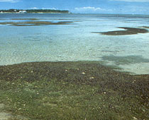
The Texas Parks and Wildlife Department (TPWD) Habitat Assessment Team is in the process of mapping aquatic and intertidal habitat (including seagrass) for Aransas Bay, San Antonio Bay, Matagorda Bay, and Galveston Bay using Texas Orthoimagery Program imagery from 2015 with funding from the US Fish and Wildlife Service State Wildlife Grant (USFWS SWG)...

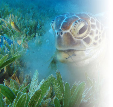
The Gulf of Mexico (GOM) Seagrass Community
of Practice (CoP) was created to support the management,
research, restoration, and conservation of seagrasses in the
GOM. The intent of the GOM Seagrass CoP is to facilitate
collaboration and coordination among seagrass experts and
practitioners to connect seagrass monitoring, mapping, research,
and management efforts; share and leverage resources and
information; and compile and implement best practices
recommendations. Seagrasses have been particularly impacted by
the degradation of coastal waters in the northern Gulf of
Mexico. Current and past assessments of the health, stability,
and well-being of the northern Gulf of Mexico supports the need
for a comprehensive collection, collation, and update of
existing seagrass data. The seagrass research and management
community has long recognized a need for comparable monitoring
and health assessment data across the Gulf of Mexico. To meet
this need, the CoP has the following goals and objectives.
Goals:
Facilitate information exchange and maximize collaboration potential by providing a mechanism for connecting experts and practitioners throughout the Gulf of Mexico. This includes a broadcast email address and a spreadsheet of contacts with affiliations, and areas of expertise.
Improve advocacy efforts for seagrass mapping/monitoring
Objectives:
Take
advantage of efficiencies by providing information on
current or planned activities that would allow others to
collaborate or benefit from project outputs, especially new
data collections.
Link to Documents - The 2020 Seagrass Status and Trends in the Northern Gulf of Mexico: 2002-2017 update by Lawrence Handley and Catherine Lockwood documents the status of seagrasses in the Northern Gulf of Mexico and provides trends in distribution and extent of occurrence. All data utilized to determine a baseline is from Tier 1 inventories collected across the Northern Gulf of Mexico and divides the northern Gulf coast into the five Gulf states and further sub-divides the coast into fourteen estuarine systems. A comparison of the five Gulf states for seagrass gains ...
Link to Documents - The 2007 Seagrass Status and Trends in the Northern Gulf of Mexico:1940-2002 edited by L. Handley, D. Altsman, and R. DeMay provides scientists, managers, and citizens with valuable baseline information on the status and trends of seagrasses in coastal waters of the Gulf of Mexico. Fourteen individual estuarine systems where seagrasses occur, as well as statewide summaries for Texas, Louisiana, Mississippi, Alabama, and Florida, are examined. Each estuarine system is detailed in vignettes that address current and historical extent and quality of seagrasses, seagrass mapping and monitoring, causes of status change, restoration and enhancement activities, background information for the entire study area as well as the subareas for study, and the methodology employed to analyze and document the historical trends and current status of seagrasses.
The Alabama Seagrass Pilot Project will assist and
inform the development of Gulf-wide Seagrass monitoring,
assessment, and reporting standards and protocols for
multiple scales. The Pilot Project can be used to
facilitate technology transfer and the dissemination of
products, lessons learned, and other materials for
Seagrass restoration practitioners.
Mission: Gain
consistency in Seagrass Monitoring for the Gulf of
Mexico Goal: Use the Alabama Pilot project as a model
for seagrass monitoring in the Gulf of Mexico.
Objectives: • Refine the Tier Approach: Tier 1 and
Tier 2 implementation in seagrass monitoring using the
Alabama Pilot Project. • Formulate a system for data
acquisitions, populating, distributions, and analysis of
seagrasses and related data for the Alabama Pilot
Project. • Provide high-quality data to state and
federal partners in Mobile Bay. The Pilot Project can be
used to provide an opportunity to demonstrate best
practices for Seagrass mapping and monitoring. These
best practices could then be applied to Seagrass mapping
and monitoring efforts across the Gulf of Mexico.